


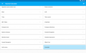


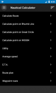


Nautical Calculator
Nautical Calculator ၏ ရွင္းလင္းခ်က္
Nautical Calculator သည် rhumb line နှင့် စက်ဝိုင်းပုံလမ်းညွှန်မှုများကို တွက်ချက်ပေးသည့် Android အပလီကေးရှင်းတစ်ခုဖြစ်သည်။
လျှောက်လွှာသည်လုံးဝအခမဲ့ဖြစ်သည်။
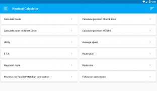
အဓိကလုပ်ဆောင်ချက်များမှာ-
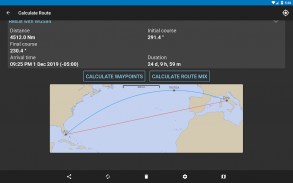
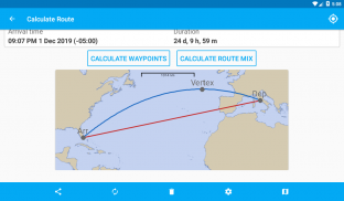
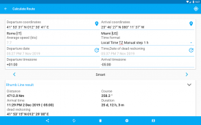
- သြဒိနိတ်နှစ်ခု၊ စက်ဝိုင်းကြီးနှင့် rhumb လိုင်းသင်တန်းများ၊ အကွာအဝေးများ၊ ကြီးမားသောစက်ဝိုင်း vertex နှင့် meridional အစိတ်အပိုင်းများကို တွက်ချက်ထားသည်၊ ဂရပ်ဖစ်ပြသည်။
- ရာထူးတစ်ခုအရ၊ ရာထူးအသစ်သည် သင်တန်းများနှင့် အကွာအဝေးအတွက် ရှေ့တိုးခြင်းဖြင့် ဆုံးဖြတ်သည်။
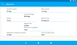
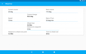
- Wheel Over တွက်ချက်ခြင်း။
- သံလိုက်အိမ်မြှောင်ထောက်လှမ်းမှုများ
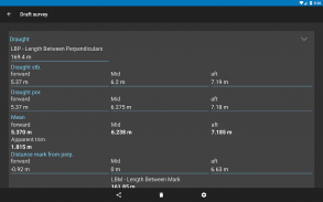
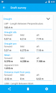
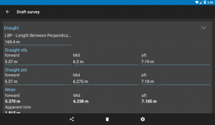
- စစ်တမ်းမူကြမ်း
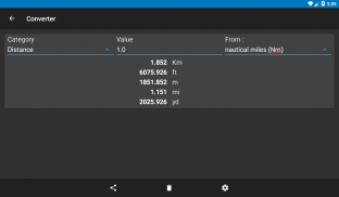
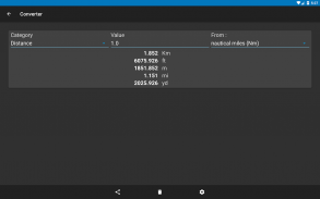
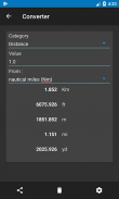
- Converter
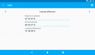
- အသုံးဝင်မှု
အခြားအင်္ဂါရပ်များကို ဖွင့်နိုင်သည်။
- ပျမ်းမျှအမြန်နှုန်းကိုတွက်ချက်ပါ။
- E.T.A. တွက်ချက်မှု
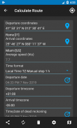
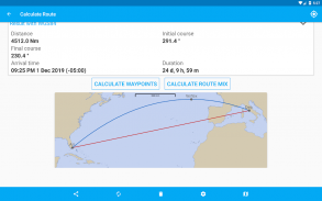
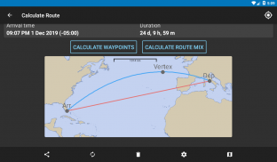
- လူကိုယ်တိုင်လမ်းကြောင်းများစီစဉ်ခြင်းအတွက် လမ်းကြောင်းအစီအစဉ်
- Waypoint လမ်းကြောင်း
- မျဉ်းပြိုင်ကန့်သတ်ချက်နှင့် ရောနှောထားသောလမ်းကြောင်း
- Rhumb Line Parallel/Meridian လမ်းဆုံ
- တူညီသော Rhumb Line လမ်းကြောင်းပေါ်တွင်လိုက်နာပါ။
- ဆန့်ကျင်ဘက်သင်တန်း rendez vous
- လမ်းကြောင်းပြုပြင်ခြင်း။
- နေဝင်ချိန်နှင့် နေထွက်ချိန်တွင် အတိုင်းအတာပမာဏကို တွက်ချက်ပါ။
- သံလိုက်အိမ်မြှောင်အမှား
- Drift ပြဿနာကိုဖြေရှင်းပါ။
- ဒီရေပြဿနာကိုဖြေရှင်းပါ။
- Tidal လက်ရှိပြဿနာကိုဖြေရှင်းပါ။
- အရိုးအကြောရှင်းလင်းခြင်းပြဿနာကို ဖြေရှင်းပါ။
- Beaufort အမျိုးအစားခွဲခြားခြင်းဖြင့်လေအားတွက်ချက်
- ABC ဇယားများ (အဇီမတ်၊ ကနဦးလမ်းစဉ်၊ မသိသောကြယ်ဖြင့် မှန်ကန်သော တက်ကြွမှု)
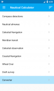
- ရေကြောင်းပြခန်း
- လအဆင့်များ
- အနေအထားမျဉ်းပါရှိသော Celestial Navigation
- Meridian အကူးအပြောင်း
- ကောင်းကင်ယံကြည့်ရှုခြင်း။
- ကမ်းရိုးတန်းလမ်းကြောင်း
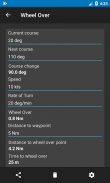
- ဘီးကျော်
- မူကြမ်းစစ်တမ်း
- Converter
- ကျောက်ချ
- ပေါင်းစည်းခြင်း။
လမ်းကြောင်းများအင်္ဂါရပ်တွင် ကမ္ဘာ့မြေပုံတစ်ခုပါရှိသည်- ၎င်းသည် ရေကြောင်းပြဇယားမဟုတ်ပါ၊ အရောင်းဇယားအဖြစ် အသုံးပြုရန်မဟုတ်၊ သို့သော် မြေကြီးပေါ်ရှိ ရေမှတစ်ဆင့် သင်တန်းများကိုပြသခြင်း၏ ရိုးရှင်းသော ယေဘုယျနည်းလမ်းအနေဖြင့် ဤမြေပုံသည် သွားလာရေးရည်ရွယ်ချက်အတွက် မဟုတ်ပါ။ .
facebook မှာ follow လုပ်ပါ။
https://www.facebook.com/NauticalCalculator
Nautical Calculator - ဗားရွင္း 11.0.2
(18-01-2025)Nautical Calculator - APK သတင္းအခ်က္အလက္
APK ဗားရွင္း: 11.0.2package: com.gabrielegi.nauticalcalculationNautical Calculator ၏ ေနာက္ဆုံးဗားရွင္း
အျခား ဗားရွင္းမ်ား


က႑တူအက္ပ္မ်ား


